
Category:Luzerne County, Pennsylvania
Counties of Pennsylvania : Adams · Allegheny · Armstrong · Beaver · Bedford · Berks · Blair · Bradford · Bucks · Butler · Cambria · Cameron · Carbon · Centre · Chester · Clarion · Clearfield · Clinton · Columbia · Crawford · Cumberland · Dauphin · Delaware · Elk · Erie · Fayette · Forest · Franklin · Fulton · Greene · Huntingdon · Indiana · Jefferson · Juniata · Lackawanna · Lancaster · Lawrence · Lebanon · Lehigh · Luzerne · Lycoming · McKean · Mercer · Mifflin · Monroe · Montgomery · Montour · Northampton · Northumberland · Perry · Philadelphia · Pike · Potter · Schuylkill · Snyder · Somerset · Sullivan · Susquehanna · Tioga · Union · Venango · Warren · Washington · Wayne · Westmoreland · Wyoming · York
county in Pennsylvania, United States   | |||||
| Upload media | |||||
| Instance of |
| ||||
|---|---|---|---|---|---|
| Named after | |||||
| Location | Pennsylvania | ||||
| Capital | |||||
| Headquarters location | |||||
| Inception |
| ||||
| Population |
| ||||
| Area |
| ||||
| Different from | |||||
| official website | |||||
 | |||||
Subcategories
This category has the following 17 subcategories, out of 17 total.
A
D
E
G
H
L
N
P
S
T
Media in category "Luzerne County, Pennsylvania"
The following 109 files are in this category, out of 309 total.
(previous page) (next page)-
 Salem Creek looking downstream.JPG 2,056 × 3,088; 2.67 MB
-
 Salem Creek looking upstream.JPG 1,722 × 2,985; 2.38 MB
-
 Salem Creek.JPG 2,448 × 3,264; 2.98 MB
-
 Salem Township and the Susquehanna River from Council Cup.JPG 2,939 × 1,818; 1.01 MB
-
 Salem Township, Luzerne County, Pennsylvania from Council Cup 2.JPG 2,256 × 1,504; 1.37 MB
-
 Solomon Creek at Lower Falls.PNG 296 × 401; 141 KB
-
 Solomon Creek at Upper Falls.PNG 298 × 370; 126 KB
-
 Solomon Creek in winter.jpg 2,304 × 3,456; 4.68 MB
-
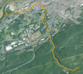 Solomon Creek satellite map.PNG 555 × 493; 673 KB
-
 Sorber Run looking downstream in its upper reaches.JPG 2,056 × 3,088; 2.85 MB
-
 South Branch Newport Creek looking downstream.jpg 2,056 × 3,088; 5.91 MB
-
 State Route 1415 heading southbound through Harveys Lake.jpg 1,600 × 1,200; 212 KB
-
 Streambed of Kitchen Creek.JPG 2,256 × 1,504; 2.82 MB
-
 Streambed of Phillips Creek.JPG 2,256 × 1,504; 2.56 MB
-
 Surface of Huntington Creek.JPG 2,253 × 1,435; 2.33 MB
-
 Surface of Kitchen Creek.JPG 2,256 × 1,504; 3.19 MB
-
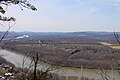
 Susquehanna River and mountains to the east.JPG 3,072 × 1,866; 1.68 MB
-
 Susquehanna River and Salem Township, Luzerne County, Pennsylvania from Council Cup.JPG 2,256 × 1,504; 1.87 MB
-
 Susquehanna River and Shickshinny Mountain.JPG 2,816 × 2,112; 1.71 MB
-
 Susquehanna River below Bell Bend.JPG 2,256 × 1,409; 2.53 MB
-
 Susquehanna River from Council Cup 1.JPG 2,866 × 2,044; 1.23 MB
-
 Susquehanna River from Council Cup 2.JPG 2,147 × 1,377; 1.59 MB
-
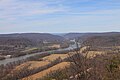 Susquehanna River from Council Cup.JPG 2,256 × 1,504; 2.08 MB
-
 Susquehanna River looking downstream from Council Cup.JPG 2,256 × 1,504; 2.92 MB
-
 Susquehanna River near Shickshinny, Pennsylvania.JPG 3,264 × 2,448; 1.54 MB
-
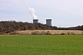
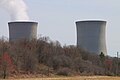 Susquehanna Steam Electric Station cooling towers close up.JPG 3,088 × 2,056; 1.26 MB
-
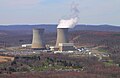
 Susquehanna Steam Electric Station cooling towers from Nescopeck.JPG 3,088 × 2,056; 1.16 MB
-
 Susquehanna Steam Electric Station cooling towers.JPG 3,088 × 2,056; 1.56 MB
-
 Susquehanna Steam Electric Station from Council Cup 2 edit.JPG 2,218 × 1,446; 1.18 MB
-
 Susquehanna Steam Electric Station from Council Cup 2.JPG 2,218 × 1,446; 1.65 MB
-
 Susquehanna Warrior Trail near the Pennsylvania Route 239 bridge.JPG 2,056 × 3,088; 2.96 MB
-
 Sylvan Lake watershed sign 1.JPG 2,256 × 1,504; 1.87 MB
-
 Sylvan Lake watershed sign 2.JPG 1,636 × 1,501; 2.01 MB
-
 The Glen Summit Hotel Postcard 1.jpg 375 × 243; 25 KB
-
.tif/lossy-page1-120px-The_Helme_Tavern%2C_238_Wyoming_Avenue%2C_Kingston%2C_Luzerne_County%2C_PA_HABS_PA%2C40-KING%2C1-_(sheet_0_of_16).tif.jpg)
-
.tif/lossy-page1-120px-The_Helme_Tavern%2C_238_Wyoming_Avenue%2C_Kingston%2C_Luzerne_County%2C_PA_HABS_PA%2C40-KING%2C1-_(sheet_1_of_16).tif.jpg)
-
.tif/lossy-page1-120px-The_Helme_Tavern%2C_238_Wyoming_Avenue%2C_Kingston%2C_Luzerne_County%2C_PA_HABS_PA%2C40-KING%2C1-_(sheet_10_of_16).tif.jpg)
-
.tif/lossy-page1-120px-The_Helme_Tavern%2C_238_Wyoming_Avenue%2C_Kingston%2C_Luzerne_County%2C_PA_HABS_PA%2C40-KING%2C1-_(sheet_11_of_16).tif.jpg)
-
.tif/lossy-page1-120px-The_Helme_Tavern%2C_238_Wyoming_Avenue%2C_Kingston%2C_Luzerne_County%2C_PA_HABS_PA%2C40-KING%2C1-_(sheet_12_of_16).tif.jpg)
-
.tif/lossy-page1-120px-The_Helme_Tavern%2C_238_Wyoming_Avenue%2C_Kingston%2C_Luzerne_County%2C_PA_HABS_PA%2C40-KING%2C1-_(sheet_13_of_16).tif.jpg)
-
.tif/lossy-page1-120px-The_Helme_Tavern%2C_238_Wyoming_Avenue%2C_Kingston%2C_Luzerne_County%2C_PA_HABS_PA%2C40-KING%2C1-_(sheet_14_of_16).tif.jpg)
-
.tif/lossy-page1-120px-The_Helme_Tavern%2C_238_Wyoming_Avenue%2C_Kingston%2C_Luzerne_County%2C_PA_HABS_PA%2C40-KING%2C1-_(sheet_2_of_16).tif.jpg)
-
.tif/lossy-page1-120px-The_Helme_Tavern%2C_238_Wyoming_Avenue%2C_Kingston%2C_Luzerne_County%2C_PA_HABS_PA%2C40-KING%2C1-_(sheet_3_of_16).tif.jpg)
-
.tif/lossy-page1-120px-The_Helme_Tavern%2C_238_Wyoming_Avenue%2C_Kingston%2C_Luzerne_County%2C_PA_HABS_PA%2C40-KING%2C1-_(sheet_4_of_16).tif.jpg)
-
.tif/lossy-page1-120px-The_Helme_Tavern%2C_238_Wyoming_Avenue%2C_Kingston%2C_Luzerne_County%2C_PA_HABS_PA%2C40-KING%2C1-_(sheet_5_of_16).tif.jpg)
-
.tif/lossy-page1-120px-The_Helme_Tavern%2C_238_Wyoming_Avenue%2C_Kingston%2C_Luzerne_County%2C_PA_HABS_PA%2C40-KING%2C1-_(sheet_6_of_16).tif.jpg)
-
.tif/lossy-page1-120px-The_Helme_Tavern%2C_238_Wyoming_Avenue%2C_Kingston%2C_Luzerne_County%2C_PA_HABS_PA%2C40-KING%2C1-_(sheet_7_of_16).tif.jpg)
-
.tif/lossy-page1-120px-The_Helme_Tavern%2C_238_Wyoming_Avenue%2C_Kingston%2C_Luzerne_County%2C_PA_HABS_PA%2C40-KING%2C1-_(sheet_8_of_16).tif.jpg)
-
.tif/lossy-page1-98px-The_Helme_Tavern%2C_238_Wyoming_Avenue%2C_Kingston%2C_Luzerne_County%2C_PA_HABS_PA%2C40-KING%2C1-_(sheet_9_of_16).tif.jpg)
-
 The Ice Ponds 1.JPG 3,088 × 2,056; 1.42 MB
-
 The Ice Ponds 3.JPG 2,822 × 2,040; 1.01 MB
-
_(14786911273).jpg/120px-The_story_of_some_French_refugees_and_their_%22Azilum%2C%22_1793-1800_(1903)_(14786911273).jpg) The story of some French refugees and their "Azilum," 1793-1800 (1903) (14786911273).jpg 3,076 × 2,134; 495 KB
The story of some French refugees and their "Azilum," 1793-1800 (1903) (14786911273).jpg 3,076 × 2,134; 495 KB
-
 Thomas F. Heffernan.jpg 750 × 983; 169 KB
-
 Toby Creek in the late 1800s or early 1900s.JPG 336 × 226; 25 KB
-

-

-

-

-

-

-

-

-

-

-
 Top of a waterfall on Maple Run.JPG 2,256 × 1,504; 2.7 MB
-
_(9925689323).jpg/120px-Traffic_Flow_(1)_(9925689323).jpg) Traffic Flow (1) (9925689323).jpg 5,184 × 2,504; 6.47 MB
Traffic Flow (1) (9925689323).jpg 5,184 × 2,504; 6.47 MB
-
 Trail in Pennsylvania State Game Lands Number 57.JPG 2,644 × 2,056; 2.82 MB
-
.tif/lossy-page1-120px-Transverse_Sections_of_Upper_and_Lower_Chutes%2C_and_Fasteners_-_Bear_Trap_Dam%2C_State_Route_115%2C_Stoddartsville%2C_Luzerne_County%2C_PA_HAER_PA-646_(sheet_4_of_4).tif.jpg)
-
 Trolley at Harvey's Lake PA 1912.JPG 1,255 × 841; 377 KB
-
 Trout Brook.jpg 2,056 × 3,088; 2.85 MB
-
 Turtle Creek looking upstream 1.JPG 2,056 × 3,088; 2.08 MB
-
 Turtle Creek looking upstream 2.JPG 3,088 × 2,056; 2.08 MB
-
.tif/lossy-page1-120px-Union_Reformed_and_Lutheran_Church%2C_Wapwallopen%2C_Luzerne_County%2C_PA_HABS_PA%2C40-WAP%2C1-_(sheet_0_of_8).tif.jpg)
-
.tif/lossy-page1-120px-Union_Reformed_and_Lutheran_Church%2C_Wapwallopen%2C_Luzerne_County%2C_PA_HABS_PA%2C40-WAP%2C1-_(sheet_1_of_8).tif.jpg)
-
.tif/lossy-page1-120px-Union_Reformed_and_Lutheran_Church%2C_Wapwallopen%2C_Luzerne_County%2C_PA_HABS_PA%2C40-WAP%2C1-_(sheet_2_of_8).tif.jpg)
-
.tif/lossy-page1-120px-Union_Reformed_and_Lutheran_Church%2C_Wapwallopen%2C_Luzerne_County%2C_PA_HABS_PA%2C40-WAP%2C1-_(sheet_3_of_8).tif.jpg)
-
.tif/lossy-page1-120px-Union_Reformed_and_Lutheran_Church%2C_Wapwallopen%2C_Luzerne_County%2C_PA_HABS_PA%2C40-WAP%2C1-_(sheet_4_of_8).tif.jpg)
-
.tif/lossy-page1-120px-Union_Reformed_and_Lutheran_Church%2C_Wapwallopen%2C_Luzerne_County%2C_PA_HABS_PA%2C40-WAP%2C1-_(sheet_5_of_8).tif.jpg)
-
.tif/lossy-page1-120px-Union_Reformed_and_Lutheran_Church%2C_Wapwallopen%2C_Luzerne_County%2C_PA_HABS_PA%2C40-WAP%2C1-_(sheet_6_of_8).tif.jpg)
-
.tif/lossy-page1-120px-Union_Reformed_and_Lutheran_Church%2C_Wapwallopen%2C_Luzerne_County%2C_PA_HABS_PA%2C40-WAP%2C1-_(sheet_7_of_8).tif.jpg)
-
.tif/lossy-page1-120px-Union_Reformed_and_Lutheran_Church%2C_Wapwallopen%2C_Luzerne_County%2C_PA_HABS_PA%2C40-WAP%2C1-_(sheet_8_of_8).tif.jpg)
-
 Unnamed tributary of Maple Run.JPG 2,256 × 1,504; 3.33 MB
-
.tif/lossy-page1-120px-Upper_Chute_Plan_and_Section_-_Bear_Trap_Dam%2C_State_Route_115%2C_Stoddartsville%2C_Luzerne_County%2C_PA_HAER_PA-646_(sheet_2_of_4).tif.jpg)
-
 USA Luzerne County, Pennsylvania age pyramid.svg 520 × 600; 8 KB
-
 USGS National Map Viewer of Nescopeck Borough and Township, Pennsylvania.png 1,600 × 870; 3.31 MB
-
 View from Council Cup's Overlook Trail.JPG 2,256 × 1,504; 2.82 MB
-

-
 View of New Columbus, Pennsylvania from Fishing Creek Township 1.JPG 2,256 × 1,504; 2.62 MB
-
 View of New Columbus, Pennsylvania from Fishing Creek Township 2.JPG 2,256 × 1,504; 2.52 MB
-
 View of New Columbus, Pennsylvania from Fishing Creek Township 3.JPG 2,256 × 1,504; 3.26 MB
-

-
_WITH_THEIR_CANVAS_COVERS%2C_LOOKING_NORTHEAST._NOTE_CONCRETE_CONSTRUCTION._THE_FOUR_LIGHT_WINDOWS_AND_THE_STEEL_EAM_FOR_THE_10-TON_HAND_HAER_PA%2C40-EDW%2C1-12.tif/lossy-page1-96px-thumbnail.tif.jpg)
-

-

-

-

-

-
 W-B River Common Night.png 1,108 × 500; 885 KB
-
 Wadham Creek.jpg 2,056 × 3,088; 5.03 MB
-
 Walker Run looking downstream 1.JPG 2,056 × 2,773; 2.41 MB
-
 Walker Run looking downstream 2.JPG 3,088 × 2,056; 3.01 MB
-
 Walker Run looking upstream.JPG 2,056 × 3,088; 2.86 MB
-
 Wapwallopen CouncilCup.jpg 383 × 263; 18 KB
-
 Wapwallopen, Pennsylvania from Council Cup 2.JPG 1,504 × 2,256; 2.88 MB
-
 Waterfall on Maple Run 1.JPG 2,256 × 1,504; 2.28 MB
-
 Waterfall on Maple Run 2.JPG 2,256 × 1,504; 2.19 MB
-
 Watering Run looking downstream.JPG 2,056 × 3,088; 2.87 MB
-
 Watering Run looking upstream.JPG 1,866 × 2,953; 2.88 MB
-
_logo.png/120px-WSJR_(Nash_FM_93.7)_logo.png) WSJR (Nash FM 93.7) logo.png 374 × 443; 21 KB
WSJR (Nash FM 93.7) logo.png 374 × 443; 21 KB


_(14786911273).jpg)


_(9925689323).jpg)


_logo.png)